"When the settlers came back, the Indians were gone forever, except for the forlorn visitors who straggled back from the West for many years to view the beautiful country that had been a happy home."
From Johhny Appleseed: Man and Myth by Robert Price, page 100.
1/31/2011
1/29/2011


1/26/2011
"The Lord spoke to Moses, saying, 'Command the people of Israel, and say to them, 'When you enter the land of Canaan (this is the land that shall fall to you for an inheritance, the land of Canaan as defined by its borders), your south side shall be from the wilderness of Zin alongside Edom, and your southern border shall run from the end of the Salt Sea on the east. And your border shall turn south of the ascent of Akrabbim, and cross to Zin, and its limit shall be south of Kadesh-barnea. Then it shall go on to Hazar-addar, and pass along to Azmon. And the border shall turn from Azmon to the Brook of Egypt, and its limit shall be at the sea.
"''For the western border, you shall have the Great Sea and its coast. This shall be your western border.
"''This shall be your northern border: from the Great Sea you shall draw a line to Mount Hor. From Mount Hor you shall draw a line to Lebo-hamath, and the limit of the border shall be at Zedad. Then the border shall extend to Ziphron, and its limit shall be at Hazar-enan. This shall be your northern border.
"''You shall draw a line for your eastern border from Hazar-enan to Shepham. And the border shall go down from Shepham to Riblah on the east side of Ain. And the border shall go down and reach to the shoulder of the Sea of Chinnereth on the east. And the border shall go down to the Jordan, and its limit shall be at the Salt Sea. This shall be your land as defined by its borders all around.''"
Numbers 34:1-12
"By faith Abraham obeyed when he was called to go out to a place that he was to receive as an inheritance. And he went out, not knowing where he was going. By faith he went to live in the land of promise, as in a foreign land, living in tents with Isaac and Jacob, heirs with him of the same promise. For he was looking forward to the city that has foundations, whose designer and builder is God. [...]
"These all died in faith, not having received the things promised, but having seen them and greeted them from afar, and having acknowledged that they were strangers and exiles on the earth. For people who speak thus make it clear that they are seeking a homeland. If they had been thinking of that land from which they had gone out, they would have had opportunity to return. But as it is, they desire a better country, that is, a heavenly one. Therefore God is not ashamed to be called their God, for he has prepared for them a city."
Hebrews 11:8-10, 13-15
1/25/2011

1/21/2011


1/16/2011

Emmet Gowin, Newly Mown Alfalfa Disturbed by a Storm, on the Snake River Plain Near the Confluence of the Columbia River, Washington, 1991.
"So, I started to travel, began to make what I call 'working landscapes', and in a simple way, I was very attracted to people like Robert Smithson. When I began to travel and look at the landscape, I saw that what I liked about what was being done in galleries worked so much better when it was in the living landscape. Then it wasn’t just a pattern across the gallery floor and a symbolic world, but it had all these forces of nature clawing at it, working it, and the human thing that was being made always had to alter itself and accommodate what nature was doing to it. I just love looking at the natural landscape. And I love the hand of the human being on the landscape. The Earthworks people were really collaborative artists with nature. Symbolically I was for what they were for, but in execution the work looked like baby talk. It was on such an unsubtle scale compared to a four or five hundred year old field that’s been under constant cultivation. That represents something of tremendous subtlety, and is actually more integrated than our eyes are really able to understand. The point for me in photographing the land was to try to introduce and reassociate myself with that subtlety. Often it would be years after taking the picture that I would realize: that’s why I did that. That was not an irrational or an arbitrary move, it’s related to the way things are in action on the landscape. And that’s a pretty important point, that the living landscape is a field of action, not stasis. It’s constantly evolving and adapting. One of the things that was sad for me about art practice was trying to bring the understanding of the natural world into the gallery. I knew that the photo was cut out and separate from the natural process, but it had a proper relationship. It was a time slice out of the natural process. And it had a secondary value, it was a comparative evidence against the changes. A field seen a second time or a third time is not ever the same."
From this mind-blowing interview.
“About the time of the survey of the lands in the United States military district, northwest of the river Ohio, preparatory to their location by those holding the warrants which had been issued by the government to the soldiers of the revolutionary war, for services during that war, there came to the valley of the Muskingum and its tributaries, the Tuscarawas, Walhonding, Mohican, &c., a man whose real name, if ever known, is not now remembered by the oldest inhabitants here, but who was commonly known and called all over the country by the name of Johnny Appleseed. [...]
“Immediately upon his advent, he commenced the raising of apple trees from the seed, at a time when there were not, perhaps fifty white men within the forty miles square. He would clear a few rods of ground in some open part of the forest, girdle the trees standing upon it, surround it with a brush fence, and plant his apple seeds. This done, he would go off some twenty miles or so, select another favorable spot, and again go through the same operation. In this way, without family and without connection, he rambled from place to place, and employed his time, I may say his life.
“When the settlers began to flock in and open their ‘clearings’, old Appleseed was ready for them with his young trees; and it was not his fault if everyone of them had not an orchard planted out and growing without delay.”
Hovey’s Magazine of Horticulture, April 1846
“The urgent need of the frontiersman for apples is something that the twentieth century can easily overlook. […] It is hard to realize that in the pioneer history of most American communities the first apple crop once marked a first stage of permanency. No other fruit could be started so easily, and none could be put to so many essential uses.” (pg. 39)
“Every settler, therefore, hoped to have a goodly plot of appletrees set out and bearing in the shortest stretch of time. Often, the trees were even a legal prerequisite to a claim, as in Kentucky’s ‘Sapphire Country’ where the planting of appleseeds or peachstones was a common guarantee to warrant the establishment of a title. At Marietta, when the Ohio Company in 1792 set up the ‘Donation Tract’ to encourage migrations to the backlands up the Muskingum and Duck Creek, they stipulated specifically that to acquire a hundred acres a settler put out not less than fifty appletrees and twenty peachtrees within three years. When orchards had been established, the land had been mastered.” (pg. 40)
“But it was seedling stock that started the pioneer apple orchards across America. Not that grafting and budding were unknown. These arts were already highly developed in the 1790’s. But the transporting of such stock into new country was a difficult and expensive venture. When trips from Connecticut to Ohio often took many weeks, a considerable number of young grafted appletrees would have pre-empted precious baggage space needed for family essentials, and would have demanded a constant vigil to keep the tender roots moist and alive.” (pg. 41)
“A few seedlings in every lot were bound by the law of chance to be fairly good, and some would be superior. Sooner or later a Northern Spy would appear in New York, a Grimes Golden in West Virginia, and a Stark in Ohio.” (pg. 42)
“In time, apples would even pioneer in a broader commerce, for apple brandy from the trees that spread over the Ohio Valley’s hillsides in the first wave of settlement would be one of the first important inland products to be shipped down the Mississippi to the markets of New Orleans.” (pg. 40)
All from Robert Price's 1954 book Johnny Appleseed: Man and Myth.


1/11/2011


1/09/2011

Pamela Pecchio, Hide the Sun

Pamela Pecchio, The Prisoner
Both from her show On Longing, Distance and Heavy Metal.
"The rich, large-scale photographs are inspired by Heavy Metal music and the artist's emotional state during a time when her home and professional life existed in two separate cities. The artist connected to the landscape as she drove between the two places, and began to photograph it. The resulting images are psychological interiors layered as densely as the music that got her through the distance.
"Made at dusk and dawn with a view camera the photographs invite the viewer to engage. Pecchio describes a dedicated listener of metal to be 'enveloped by the sound, temporarily held inside the tangled web it creates.' In this work, she looks for photographs that hold the viewer in a similar space, finding visual rhythm and dissonance in the landscape of North Carolina and Virginia."
Text from here.
1/08/2011


1/07/2011


1/06/2011

1/05/2011

John Pfahl, Canyon Point, Zion National Park, Utah (October 1977)

John Pfahl, Moonrise over Pie Pan, Capital Reef National Park, Utah (October 1977)

John Pfahl, Roan Mountain Lightning, Roan Mountain, North Carolina

John Pfahl, Green Hill Lightning, Arches National Park, Utah (October 1977)
All From John Pfahl's Altered Landscape series.
1/04/2011

"The Northern Divide is not just of geographic and hydrologic importance, but it has political significance too. When the Louisiana Purchase was added to the United States in 1803, the Northern Divide served as the boundary between the territory of the United States and Great Britain (Canada). The present-day boundary between the United States and Canada was not established until 1818, when the Treaty of Ghent set the international boundary at 49º N latitude.
"The Northern Divide still has important political ramifications, because water in North Dakota drains into Canada. For example, Manitoba is citing international water laws, treaties, and compacts in its concerns over the Northwest Water Pipeline, which diverts water from the Missouri River to Minot, the proposed Garrison Diversion, which would divert Missouri River water to all of eastern North Dakota, and the planned Devils Lake outlet, which would transfer water from a closed basin to the Sheyenne/Red River system."
Information about continental divides in the United States here, at the National Atlas site. Picture from here.


The check that bought Alaska and the Apollo 11 flight plan, also via the U.S. National Archives and Records Administration.
"This transition from a 'wild' western frontier into organized segments of a federal union is documented in photographs. Private citizens and Government officials took the recently developed camera on their western adventures to record nature's curious sights and the marks that they as men and women made on the landscape."
From the U.S. National Archives and Records Administration's article "Photographs of the American West: 1861-1912."

A member of Clarence King's Geological Exploration of the 40th Parallel is surveying from a rock. Shoshone Canyon and Falls, Idaho Terr., in background. By O'Sullivan, 1868.

Timothy O'Sullivan's ambulance wagon and portable darkroom used during the King Survey rolls across the sand dunes of Carson Desert, Nev. By O'Sullivan, 1867.

"Rebuilding Monument 40." By D. H. Payne, under the direction of the U.S. section of the International Boundary Commission, along the Mexican border west of the Rio Grande, 1892--94.

"Gen. William T. Sherman and commissioners in council with Indian chiefs at Ft. Laramie, Wyo.." ca. 1867--68.

"Big Foot, leader of the Sioux, captured at the battle of Wounded Knee, S.D." Here he lies frozen on the snow-covered battlefield where he died, 1890.

"Villa of Brule. The great hostile Indian camp on River Brule near Pine Ridge, S. D." By Grabill, 1891.

"The William B. Douglas party, including Navaho and Paiute Indians, celebrate their discovery of Rainbow Bridge, Utah, as they eat watermelon in Paiute Canyon, 1909."

"Irrigation ditch under construction at San Carlos Indian Agency, Arizona-1 886."

"Lamon's log cabin, the first built in Yosemite Valley, Calif." Their work completed, two men sit on stumps in front of the finished product, ca. 1895.

"Oklahoma Cotton Field." Overseer and Negro cottonpickers, ca. 1897--98.

"Gathering the Fruits of an Oklahoma Farm--Apples, Peaches, Plums, Pears, Grapes, and Melons." Children at their chores, ca. 1900.

Panoramic view of California wheatfield, windmill, and ranch buildings at foot of mountains. By C. Hart Merriam, 1903.

"Chinese drying shrimps and mending nets, ca. 1889." San Francisco Bay By Townsend.

Italian fishermen mending nets on wharf at foot of Union Street in San Francisco. Boats are lined up on the wharf for painting and repairs, ca. 1891.
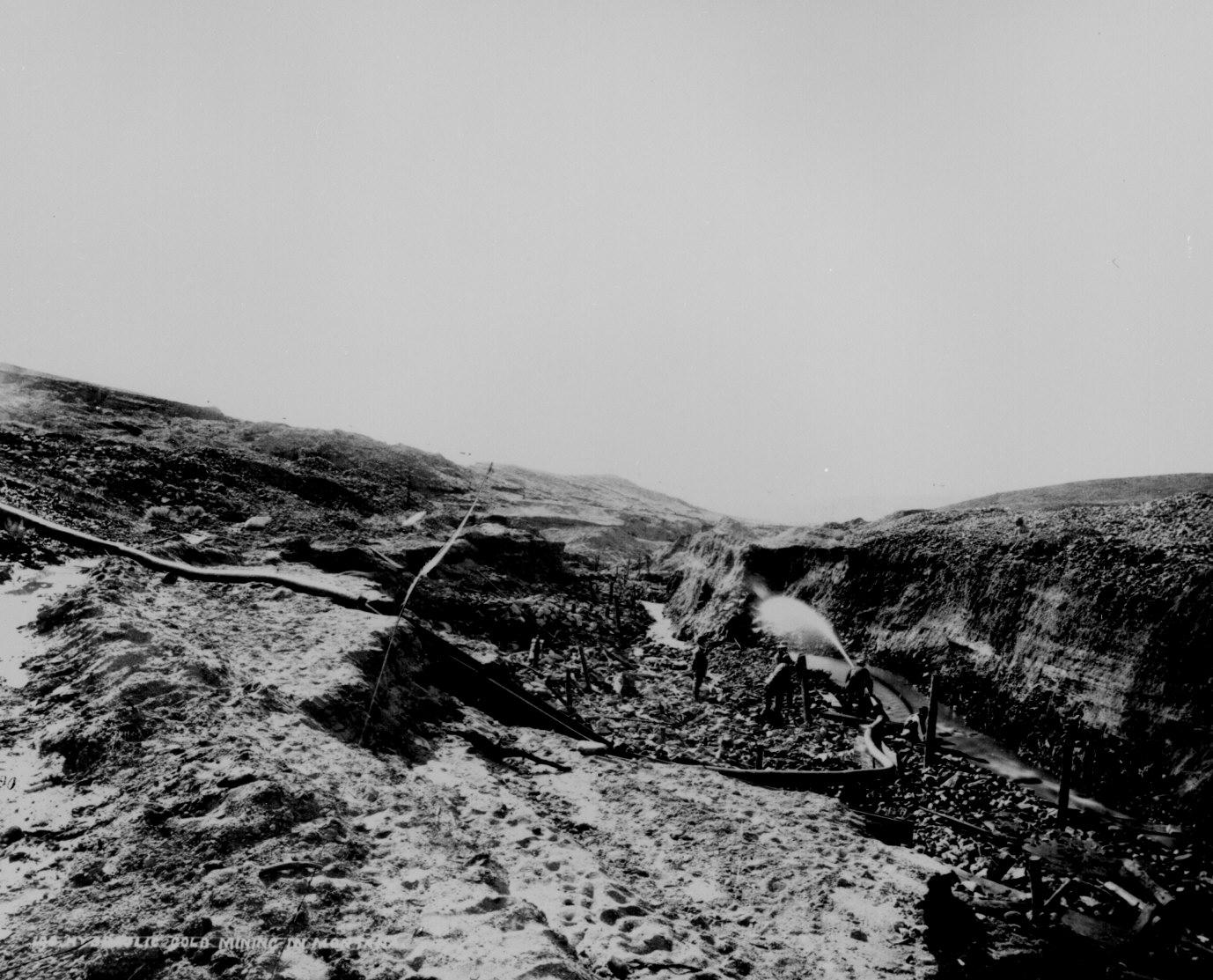
Hydraulic gold mining near Virginia City, Mont. Terr. A flume is laid upon bedrock in the bottom of Alder Gulch and the waters of the creek brought through it, carrying the auriferous sand. The sides of the gulch are washed away into sluiceboxes where the gold is collected. By Jackson, 1871.

Quarrying granite for the Mormon Temple, Utah Territory. The ground is strewn with boulders and detached masses of granite, which have fallen from the walls of Cottonwood Canyon. The quarrying consists of splitting up the blocks.

Panoramic view of reduction works and copper mines, Globe, Ariz. Terr., ca. 1898--99.

Loading coal in the strip pits, Wilburton, Indian Terr. [Oklahoma], ca. 1898.

The Mesabi Range. A panoramic view of the Shenango iron mine, ca. 1910. Beginning in 1892, the rich Mesabi Range in northern Minnesota was a major source of high--grade iron ore.

"Looking For A Town Lot." Guthrie, Ind. Terr. [Oklahoma], ca. 1889.

"Holding Down A Lot In Guthrie." By C. P. Rich, ca. 1889.

"In Line At The land Office, Perry, Sept. 23, 1893. 9 o'clock A.M. waiting to file."

W. H. McCoy's claim, Perry, Okla. Terr., October 1, 1893.

"Anadarko Townsite [Okla. Terr.] Aug. 6, [1901]--a cornfield."

"First Auction Sale of Lots at Imperial April 12, 1904." Inside the tent with the California Development Co. and hopeful landowners.

"Gardiner Park Co., Montana, Looking North East, 1887." A onesided street backed up to rocky foothills.

"Nogales, Santa Cruz Co. Showing boundary line between Arizona and Mexico." General view of center of town from hillside, looking west along International Street, ca. 1898-1899. By W I Neumann.

"City of Imperial, from ice plant water tank, July 9, 1904." Panoramic view.

"Cleveland. The City of Oil Derricks." Panoramic view of an Oklahoma Territory town a year after the discovery of oil there. By Dick Man, 1905.

"Claims bought and sold. U.S. Land Office practice--contests a specialty." Attorneys and surveyors in front of office, west of Court House Square, Round Pond, Okla. Terr. By Kennett, January 1894.

"Territorial University at Norman." Oklahoma Terr., ca. 1897-98.

"Sunday school, Indians and white[s]." Indian Territory [Oklahoma], ca. 1900.

"Cliff House and Seal Rocks." An outing at the beach in San Francisco. By Peabody, 1902.

Townspeople of Ehrenburg, Ariz. Terr., greet a stranger in an automobile on his pioneer cross country tour. Saloon in background. By A. L. Westgard, ca. 1911.

"In Wind Cave, S.D. 350 feet below the surface at Odd Fellows' Hall." William Jennings Bryan and Governor Lee in center front of group. By W. R. Cross, ca. 1897.
Subscribe to:
Posts (Atom)