"This transition from a 'wild' western frontier into organized segments of a federal union is documented in photographs. Private citizens and Government officials took the recently developed camera on their western adventures to record nature's curious sights and the marks that they as men and women made on the landscape."
From the U.S. National Archives and Records Administration's article "Photographs of the American West: 1861-1912."

A member of Clarence King's Geological Exploration of the 40th Parallel is surveying from a rock. Shoshone Canyon and Falls, Idaho Terr., in background. By O'Sullivan, 1868.

Timothy O'Sullivan's ambulance wagon and portable darkroom used during the King Survey rolls across the sand dunes of Carson Desert, Nev. By O'Sullivan, 1867.

"Rebuilding Monument 40." By D. H. Payne, under the direction of the U.S. section of the International Boundary Commission, along the Mexican border west of the Rio Grande, 1892--94.

"Gen. William T. Sherman and commissioners in council with Indian chiefs at Ft. Laramie, Wyo.." ca. 1867--68.

"Big Foot, leader of the Sioux, captured at the battle of Wounded Knee, S.D." Here he lies frozen on the snow-covered battlefield where he died, 1890.

"Villa of Brule. The great hostile Indian camp on River Brule near Pine Ridge, S. D." By Grabill, 1891.

"The William B. Douglas party, including Navaho and Paiute Indians, celebrate their discovery of Rainbow Bridge, Utah, as they eat watermelon in Paiute Canyon, 1909."

"Irrigation ditch under construction at San Carlos Indian Agency, Arizona-1 886."

"Lamon's log cabin, the first built in Yosemite Valley, Calif." Their work completed, two men sit on stumps in front of the finished product, ca. 1895.

"Oklahoma Cotton Field." Overseer and Negro cottonpickers, ca. 1897--98.

"Gathering the Fruits of an Oklahoma Farm--Apples, Peaches, Plums, Pears, Grapes, and Melons." Children at their chores, ca. 1900.

Panoramic view of California wheatfield, windmill, and ranch buildings at foot of mountains. By C. Hart Merriam, 1903.

"Chinese drying shrimps and mending nets, ca. 1889." San Francisco Bay By Townsend.

Italian fishermen mending nets on wharf at foot of Union Street in San Francisco. Boats are lined up on the wharf for painting and repairs, ca. 1891.
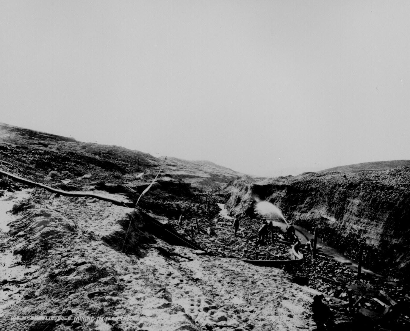
Hydraulic gold mining near Virginia City, Mont. Terr. A flume is laid upon bedrock in the bottom of Alder Gulch and the waters of the creek brought through it, carrying the auriferous sand. The sides of the gulch are washed away into sluiceboxes where the gold is collected. By Jackson, 1871.

Quarrying granite for the Mormon Temple, Utah Territory. The ground is strewn with boulders and detached masses of granite, which have fallen from the walls of Cottonwood Canyon. The quarrying consists of splitting up the blocks.

Panoramic view of reduction works and copper mines, Globe, Ariz. Terr., ca. 1898--99.

Loading coal in the strip pits, Wilburton, Indian Terr. [Oklahoma], ca. 1898.

The Mesabi Range. A panoramic view of the Shenango iron mine, ca. 1910. Beginning in 1892, the rich Mesabi Range in northern Minnesota was a major source of high--grade iron ore.

"Looking For A Town Lot." Guthrie, Ind. Terr. [Oklahoma], ca. 1889.

"Holding Down A Lot In Guthrie." By C. P. Rich, ca. 1889.

"In Line At The land Office, Perry, Sept. 23, 1893. 9 o'clock A.M. waiting to file."

W. H. McCoy's claim, Perry, Okla. Terr., October 1, 1893.

"Anadarko Townsite [Okla. Terr.] Aug. 6, [1901]--a cornfield."

"First Auction Sale of Lots at Imperial April 12, 1904." Inside the tent with the California Development Co. and hopeful landowners.

"Gardiner Park Co., Montana, Looking North East, 1887." A onesided street backed up to rocky foothills.

"Nogales, Santa Cruz Co. Showing boundary line between Arizona and Mexico." General view of center of town from hillside, looking west along International Street, ca. 1898-1899. By W I Neumann.

"City of Imperial, from ice plant water tank, July 9, 1904." Panoramic view.

"Cleveland. The City of Oil Derricks." Panoramic view of an Oklahoma Territory town a year after the discovery of oil there. By Dick Man, 1905.

"Claims bought and sold. U.S. Land Office practice--contests a specialty." Attorneys and surveyors in front of office, west of Court House Square, Round Pond, Okla. Terr. By Kennett, January 1894.

"Territorial University at Norman." Oklahoma Terr., ca. 1897-98.

"Sunday school, Indians and white[s]." Indian Territory [Oklahoma], ca. 1900.

"Cliff House and Seal Rocks." An outing at the beach in San Francisco. By Peabody, 1902.

Townspeople of Ehrenburg, Ariz. Terr., greet a stranger in an automobile on his pioneer cross country tour. Saloon in background. By A. L. Westgard, ca. 1911.

"In Wind Cave, S.D. 350 feet below the surface at Odd Fellows' Hall." William Jennings Bryan and Governor Lee in center front of group. By W. R. Cross, ca. 1897.
No comments:
Post a Comment